Dosiye:Africa (orthographic projection).svg
Dosiye nkomoko(SVG file, nominally 550 × 550 pixels, file size: 111 KB)

Ino dosiye iva kuri Wikimedia Commons ishobora kandi gukoreshwa n'iyindi migambi. Insiguro kuri urupapuro rusigura dosiye zayo zerekanwa aha hakurikira.

Incamake

Umwidondoro
العربية: الخريطة الهجائية لأفريقيا
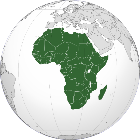
English: Orthographic map of Africa
Esperanto: Ortografia mapo de Afriko
Français : Carte orthographique de l'Afrique
हिन्दी: अफ्रीका की लेखनप्रक्षेपीय मानचित्र
Igenekerezo
Inkomoko Igikorwa cisangije
Umwanditsi Martin23230
Other versions

Derivative works of this file:

This is a Grey & green orthographic projection map.
العربية: الرجاء، قراءة الميثاق.
বাংলা: দয়া করে, রীতিনীতিটি পড়ুন
Deutsch: Bitte lies die Konventionen.
English: Please, read the conventions.
Español: Por favor, lea las convenciones.
Filipino: Paki-basa ang mga kumbensyon.
Français : S'il vous plaît, lisez les conventions.
हिन्दी: कृपया सभागमों को पढ़ लें.
Bahasa Indonesia: Silakan, baca konvensi.
Italiano: Si prega di leggere le convenzioni.
ქართული: გთხოვთ, გაეცნოთ კონვენციებს.
Português: Por favor, leia as convenções.
Русский: Пожалуйста, прочитайте соглашения.
Українська: Будь ласка, прочитайте конвенції.
Tiếng Việt: Hãy đọc công văn trước khi đăng.
World maps

Africa

हिन्दी: अफ्रीका
ქართული: აფრიკა.

Eastern Africa

Southern Africa

Central Africa

Northern Africa

Western Africa

Americas

ქართული: ამერიკა.
हिन्दी: अमेरिका

North America

Central America

Caribbean

South America

Asia

ქართული: აზია.
Português: Ásia.
Українська: Азія.

East

Português: Ásia Oriental.
Українська: Східна Азія.

Central

हिन्दी: मध्य एशिया
Português: Ásia Central.
Українська: Центральна Азія.

Southeast

Bahasa Indonesia: Asia tenggara
Português: Sudeste Asiático.

South

(भारतीय उपमहाद्वीप)
Português: Sul da Ásia.
Українська: Південна Азія.

Western

Português: Sudoeste da Ásia.
Українська: Передня Азія.

Europe

हिन्दी: यूरोप
ქართული: ევროპა.
Português: Europa.
Română: Europa.
Русский: Европа.
Українська: Європа.

Countries

Oceania

हिन्दी: ओशिआनिया
ქართული: ოკეანეთი.
Português: Oceania.
Українська: Океанія.

Intercontinental

Português: Intercontinental.
Українська: Міжконтинентальні.

Historical

English: Unions, Organizations, Kingdoms, Empires
Español: Uniones, Organizaciones, Reinos, Imperios
Filipino: Mga Unyon, Organisasyon, Kaharian, Imperyo
Français : Unions, Organisations, Royaumes, Empires
हिन्दी: संघ, संगठन, राज्य, साम्राज्य व ऐतिहासिक देश
ქართული: გაერთიანებები, ორგანიზაციები, სამეფოები, იმპერიები
Português: Estados extintos.
Tagalog: Mga Unyon, Organisasyon, Kaharian, Imperyo
Українська: Союзи, Організації, Королівства, Імперії

Subnationals

हिन्दी: उपराष्ट्रीय इकाईयाँ
SVG genesis
InfoField
 
The SVG code is valid.
 
This world map was created with Inkscape, and then manually edited
.
Camera location0° 00′ 00″ N, 15° 00′ 00″ E Kartographer map based on OpenStreetMap.View this and other nearby images on: OpenStreetMapinfo

Uburenganzira

I, the copyright holder of this work, hereby publish it under the following licenses:
w:en:Creative Commons
umurimo Imigabane ingana
Uridegemvya:
  • gusangiza – mukwimura, kwiragiza wongere utange igikorwa
  • guhinyanyura – kujanisha igikorwa
Ku mategeko akurikira:
  • umurimo – Utegerezwa gutanga inkuru injanye, tanga umurongo ku ruhushya, kandi erekana ko habaye impinduka. Urashobora kubikora muburyo ubwo aribwo bwose busiguritse, ariko atari mu buryo ubwo aribwo bwose bwerekana ko uwatanze uburenganzira agushigikiye canke ashigikiye ibikoresho vyawe.
  • Imigabane ingana – Mugihe uhinyanyuye, uhinduye, canke wisunze iki gikorwa, utegerezwa gutanga intererano zawe kuri same or compatible license kumwe n'igikorwa c'inkomoko.
GNU head Hatanzwe uruhusha rwo kwimura, gukwiragiza canke guhinyanyura ibi vyandiko hakoreshejwe uruhusha rwa GNU Free Documentation License, Umuce wa 1.2 canke umuce uwariwo wose washizeho inyuma ya Free Software Foundation; ata gice ntahinduka, ata majambo y'urupapuro rw'intango canke rw'iherezo. Kwimuru uruhusha biri mu muce witwa GNU Free Documentation License.
Ushobora gucagura uruhusha ushaka.

Captions

Add a one-line explanation of what this file represents
Total African Map Highlight

Items portrayed in this file

depicts Icongereza

map Icongereza

globe Icongereza

copyright status Icongereza

copyrighted Icongereza

inception Icongereza

25 Ruheshi 2009

0°N, 15°E

MIME type Icongereza

image/svg+xml

checksum Icongereza

e19e98608fc64212eb36c140c597b5bc5fd83702

determination method Icongereza: SHA-1 Icongereza

data size Icongereza

113774 byte

height Icongereza

550 pixel

width Icongereza

550 pixel

Amateka ya dosiye

Fyonda kw'igenekerezo/isaha kugirango urabe dosiye nkuko yagaragaye uwo mwanya.

(ya vuba cane | Ya kera cane) Raba (10 nshasha | ) (10 | 20 | 50 | 100 | 250 | 500)
Igenekerezo/IsahaIparatiUburinganireUwukoreshaInsiguro
muri iki gihe17:06, 12 Gitugutu 2022Iparati ku gice c'igihe ca 17:06, 12 Gitugutu 2022550 × 550 (111 KB)M.BittonReverted to version as of 14:01, 4 September 2022 (UTC): per COM:OVERWRITE
12:05, 12 Gitugutu 2022Iparati ku gice c'igihe ca 12:05, 12 Gitugutu 2022550 × 550 (113 KB)Рагин1987Socotra Island is geologically part of Africa
14:01, 4 Nyakanga 2022Iparati ku gice c'igihe ca 14:01, 4 Nyakanga 2022550 × 550 (111 KB)M.BittonReverted to version as of 13:07, 20 November 2021 (UTC): per COM:OVERWRITE
13:54, 4 Nyakanga 2022Iparati ku gice c'igihe ca 13:54, 4 Nyakanga 2022550 × 550 (115 KB)Рагин1987Correction
13:30, 31 Myandagaro 2022Iparati ku gice c'igihe ca 13:30, 31 Myandagaro 20222.048 × 2.048 (1,01 MB)Рагин1987Small correction (Socotra Island is geologically closer to Africa)
13:07, 20 Munyonyo 2021Iparati ku gice c'igihe ca 13:07, 20 Munyonyo 2021550 × 550 (111 KB)M.BittonReverted to version as of 19:13, 21 November 2020 (UTC): per COM:OVERWRITE. Please don't revert again.
21:02, 19 Munyonyo 2021Iparati ku gice c'igihe ca 21:02, 19 Munyonyo 2021550 × 550 (113 KB)Jacob300Reverted to version as of 19:40, 13 October 2021 (UTC)
22:58, 13 Gitugutu 2021Iparati ku gice c'igihe ca 22:58, 13 Gitugutu 2021550 × 550 (111 KB)M.BittonReverted to version as of 19:13, 21 November 2020 (UTC): per Com:Overwrite
19:40, 13 Gitugutu 2021Iparati ku gice c'igihe ca 19:40, 13 Gitugutu 2021550 × 550 (113 KB)GebageboAdded Somaliland
19:13, 21 Munyonyo 2020Iparati ku gice c'igihe ca 19:13, 21 Munyonyo 2020550 × 550 (111 KB)Christian FerrerReverted to version as of 18:52, 21 November 2020 (UTC)
(ya vuba cane | Ya kera cane) Raba (10 nshasha | ) (10 | 20 | 50 | 100 | 250 | 500)

Urupapuro rukurikira rukoresha iyi dosiye:

Ikoreshwa rya dosiye muri rusangi

Metadata